Water does much more than flow through a landscape. As it moves through soils and rocks, it drives chemical reactions that gradually transform minerals and release dissolved elements into streams. This process, known as chemical weathering, influences water chemistry and nutrient transport and plays a role in the long-term carbon cycle.
But how much does chemical weathering vary across Europe? And has it changed over recent decades?
A MSc thesis carried out within SERVICO2 has tackled these questions at a remarkable scale, combining spatial, geological and hydroclimatic information for hundreds of thousands of European headwater catchments between 1995 and 2025.
Mapping almost 223,000 headwater catchments
The study focused on the smallest streams at the beginning of river networks: first- and second-order headwater catchments. These small catchments are particularly interesting because processes occurring there can influence the chemistry of water subsequently transported downstream.
The analysis combined several European and global datasets describing catchment boundaries, geology, soils, temperature and runoff. In total, 262,619 headwater catchments were included in the database, with 222,958 catchments having complete information for the entire 31-year period.
Rather than measuring weathering directly in every stream—which would clearly be impossible at this scale—the study used a modelling approach based on geology, runoff, temperature and soil characteristics. The result is a spatially explicit estimate of fluvial chemical weathering (FCW) that can be compared across Europe and through time.
Geography matters: water and rocks work together
The resulting map reveals striking geographical differences. Some of the highest estimated weathering rates occur around the Alpine region and northern Italy, as well as in several wet areas along the Atlantic and in northern Europe. Lower rates are common in parts of eastern continental Europe and in drier areas of southern and southeastern Europe.
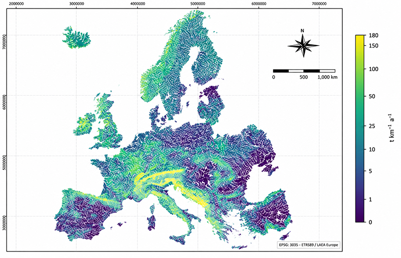
There is no single explanation for this pattern. Instead, it reflects the interaction between how much water moves through a catchment and what kinds of rocks are exposed to that water.
Carbonate rocks make a particularly important contribution. In the model, the carbonate component accounts for most of the estimated weathering rate, reflecting the high reactivity of carbonate lithologies. Across the study area, the annual area-weighted mean FCW was 15.02 t km⁻² yr⁻¹.
A variable system, but no clear European-wide trend
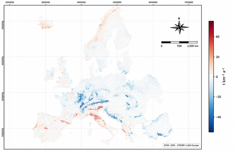
Looking across the 31 years reveals another interesting result. Chemical weathering fluctuates substantially from one year to another, but the analysis does not show a sustained linear trend at the European scale.
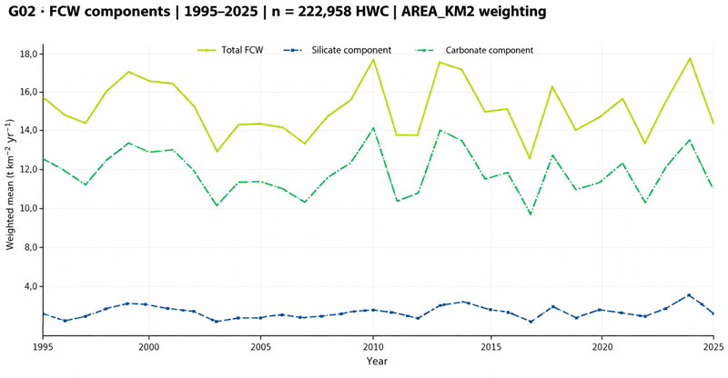
The highest area-weighted annual mean occurred in 2010 and the lowest in 2017. Although the estimated value was 15.61 t km⁻² yr⁻¹ in 1995 and 13.82 t km⁻² yr⁻¹ in 2025, analysing all 31 years produces an almost flat linear trend. This is an important reminder that comparing two individual years can give a misleading picture of a highly variable environmental process.
One factor stands out as particularly important: runoff. Years with more runoff generally produced higher modelled weathering rates. The correlation between annual total FCW and runoff was approximately 0.90. Temperature was also positively related to the silicate component, although more weakly. These relationships should be interpreted carefully, however, because runoff and temperature are themselves variables included in the model rather than an independent validation of its results.
From continental maps back to real catchments
Large-scale modelling is powerful, but it also needs to be confronted with observations from real catchments. As a first test, the study compared its estimates with independent results from seven sites in the Sant Nicolau valley in the Pyrenees.
The comparison revealed differences: the new FCW estimates were higher at all seven sites and did not reproduce their spatial ordering. This does not necessarily mean that one approach is right and the other wrong, as the two methods do not represent exactly the same chemical components. Instead, the comparison helps identify where the model needs further evaluation and where local information becomes particularly valuable.
And this is where the work connects directly with the wider objectives of SERVICO2.
A new tool for SERVICO2
Beyond producing a single European estimate, the thesis has created something particularly useful for the project: a reproducible, pan-European inventory of headwater catchments, accompanied by annual data series, maps, quality controls and processing scripts.
This provides SERVICO2 with a common framework for comparing catchments, identifying areas of interest and exploring how geology, climate and hydrology interact to control chemical weathering. The next challenge will be to connect this continental perspective with field observations and detailed knowledge from individual catchments.
Combining both scales—the broad European picture and measurements from real headwater systems—will help us better understand how these small but important catchments contribute to carbon and nutrient cycling across Europe.
About the MSc thesis
This work was developed as the MSc thesis “Estimation and analysis of fluvial chemical weathering rates in European headwater catchments (1995–2025)” (in Spanish) by Daniel Felipe Velasco Durán, Universitat Autònoma de Barcelona (2026), supervised by Lluís Camarero, Carlos Palacín Lizarbe and Lluís Pesquer.